
You drop a pin on a map to meet a friend, and suddenly, a string of strange numbers appears on your screen. You might ignore them, but those numbers are the exact mathematical address of that specific spot on Earth.
Understanding how to read Google Maps coordinates unlocks a new level of precision. Whether you are navigating a remote hiking trail, planning delivery routes for your business, or scraping geolocation data for market research, knowing your way around latitude and longitude is incredibly useful.
In this guide, you will learn exactly what those numbers mean, how to decode the GPS coordinates format, and how to use this data to your advantage.
Quick Answer: How Do You Read Google Maps Coordinates?
To read Google Maps coordinates, look at the two numbers provided. The first number is the latitude, which tells you how far north or south a location is from the Equator. The second number is the longitude, showing how far east or west it is from the Prime Meridian. Positive numbers indicate North and East, while negative numbers indicate South and West.
What Are Google Maps Coordinates?
Google Maps relies on a geographic coordinate system to pinpoint locations. Think of it as a massive grid wrapping around the globe.
This grid consists of two main components:
- Latitude: These invisible horizontal lines run parallel to the Equator.
- Longitude: These invisible vertical lines run from the North Pole to the South Pole.
When you look at Google Maps location pins, the app translates this global grid into a simple digital format. Instead of street names and zip codes, coordinates provide an absolute, unchanging location. A street name might change, but the geographic coordinates remain the same.
Google Maps Coordinate Format Explained

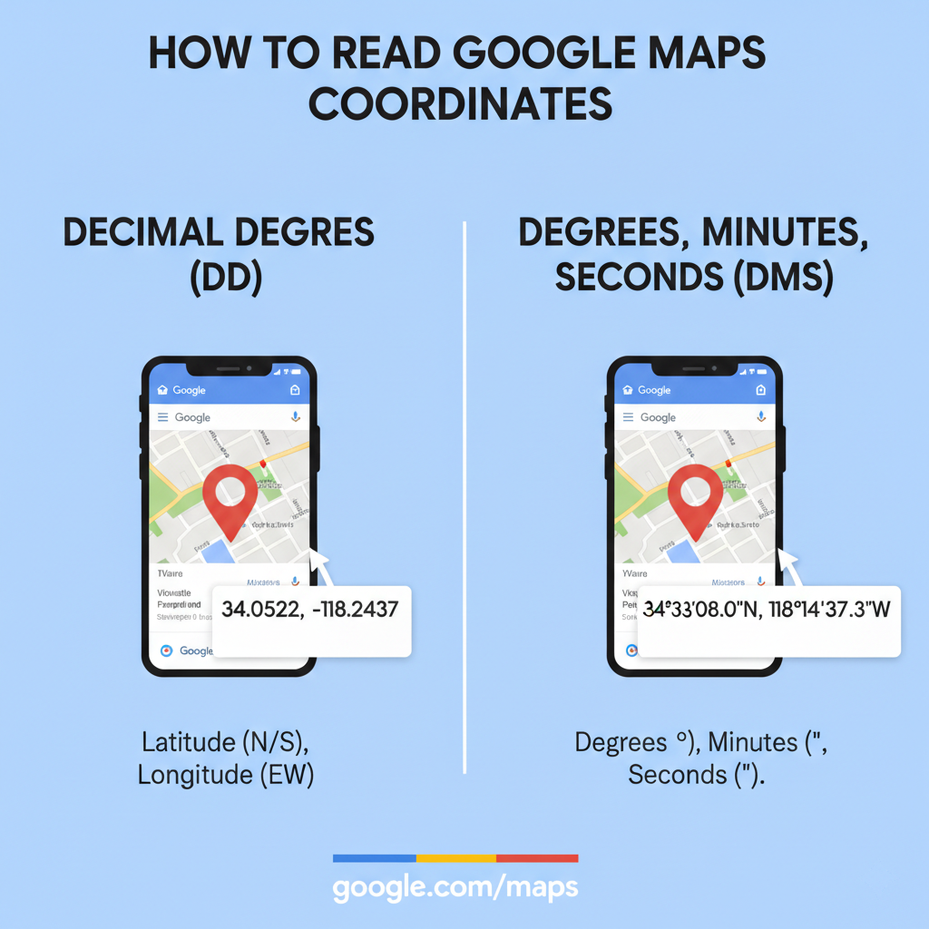
Map navigation systems generally use a few different formats to display this information. Google Maps primarily uses two formats: Decimal Degrees and Degrees, Minutes, and Seconds.
Decimal Degrees (DD)
This is the standard format you will see most often on Google Maps. It represents coordinates as simple positive or negative decimal numbers.
- Example for Dhaka: 23.8103, 90.4125
- Example for London: 51.5074, -0.1278
Degrees, Minutes, and Seconds (DMS)
This format is older and relies on a system similar to telling time. It breaks the coordinates down into degrees (°), minutes ('), and seconds ("). You will also see compass directions (N, S, E, W) attached.
- Example for London: 51° 30' 26.6" N, 0° 7' 40.1" W
Decimal Degrees vs DMS Comparison
Feature
Decimal Degrees (DD)
Degrees, Minutes, Seconds (DMS)
Appearance
40.7128, -74.0060
40° 42' 46.1" N, 74° 0' 21.6" W
Primary Use
Digital mapping, APIs, software
Traditional maps, maritime navigation
Direction Indicators
Positive/Negative signs
Letters (N, S, E, W)
How to Read Google Maps Coordinates: Step-by-Step
Reading these numbers might seem complex, but you can break them down into simple parts. Let us use the coordinates for the Eiffel Tower as an example: 48.8584, 2.2945.
Step 1: Identify Latitude First
The first number (48.8584) is always the latitude. Since it is a positive number, it means the location is in the Northern Hemisphere. If the number were negative, it would be in the Southern Hemisphere.
Step 2: Identify Longitude Second
The second number (2.2945) is always the longitude. Because this is a positive number, the location sits in the Eastern Hemisphere. A negative number would place it in the Western Hemisphere.
Step 3: Understand the Precision
The numbers after the decimal point determine the exactness of the location. A coordinate with four decimal places can pinpoint a specific street. A coordinate with six decimal places can identify individual trees or doorways.
How to Find Coordinates in Google Maps
Finding coordinates is easy, regardless of the device you use.
Desktop Method
- Open Google Maps in your web browser.
- Right-click on the exact spot you want to identify.
- A menu will appear with the coordinates listed at the very top.
- Click on the coordinates to automatically copy them to your clipboard.
Mobile Method (iOS and Android)
- Open the Google Maps app.
- Tap and hold an unmapped area of the map to drop a red pin.
- Scroll down on the information panel that appears at the bottom of your screen.
- You will see the coordinates listed, which you can tap to copy.
Common Mistakes When Reading Coordinates
Even experienced users make errors when handling geolocation data. Avoid these common traps:
- Mixing up latitude and longitude: Always remember that latitude comes first. Flipping them will send you to the wrong side of the world.
- Losing the negative sign: Forgetting to type a minus sign turns a West longitude into an East longitude.
- Wrong format usage: Ensure your GPS device or software is set to the correct format (DD vs DMS) before entering the numbers to avoid requiring a manual coordinate conversion.
How Businesses Use Coordinates
Coordinates are not just for hikers and geologists. Businesses leverage precise geolocation data to gain a competitive edge.
- Logistics and Delivery: Delivery companies use exact coordinates to guide drivers to specific loading docks, cutting down on wasted fuel and time.
- Local SEO: Marketers map out business coordinates to optimize local search campaigns and analyze competitor proximity.
- Market Research: Retailers analyze coordinate data to determine the perfect spot for a new store based on foot traffic and demographic zones.
- Lead Generation: B2B companies target businesses within specific geographic coordinates to build hyper-local contact lists.
Automating Coordinate Data Extraction
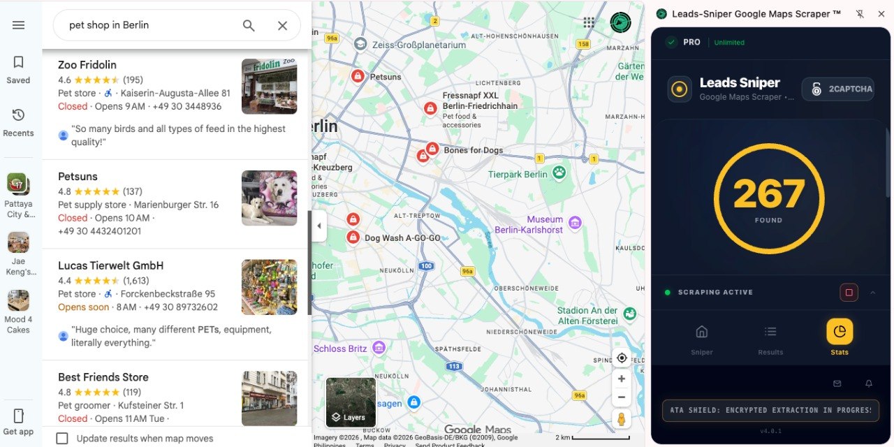
Manually right-clicking and copying coordinates works fine for one or two locations. However, if you need to gather data on hundreds of competitors or local leads, doing it by hand becomes impossible.
This is where the Google Maps Scraper by Leads Sniper comes in.
Instead of spending hours copying and pasting, this tool allows you to extract precise coordinates, business names, contact details, and location insights automatically. You simply define your search parameters, and the scraper pulls all the structured data you need directly from Google Maps into a clean spreadsheet. It is the perfect solution for marketers, sales teams, and researchers who need accurate geographic data without the tedious manual effort.
Frequently Asked Questions
What do the numbers in Google Maps coordinates mean?
The numbers represent the exact latitude (north/south) and longitude (east/west) of a location on the Earth's surface.
How do I convert coordinates?
Google Maps automatically handles coordinate conversion for you. If you paste a DMS coordinate into the search bar, Google will instantly drop a pin and display the Decimal Degrees equivalent.
Are coordinates always in decimal format?
No. While Google Maps favors Decimal Degrees for digital simplicity, many maritime, aviation, and traditional navigation tools still rely on Degrees, Minutes, and Seconds (DMS).
Can I use coordinates for business targeting?
Absolutely. Marketers and sales teams frequently use coordinate data to map out competitors, build localized lead lists, and analyze regional market saturation.
Conclusion
Learning how to read Google Maps coordinates removes the mystery from those long strings of numbers. By understanding the difference between latitude and longitude, decoding the formatting, and knowing how to extract this data, you gain precise control over geographic information.
Whether you are plotting a road trip or scraping local business data to fuel your sales pipeline, coordinates are the most accurate way to navigate the world. Open up Google Maps today, drop a pin, and start exploring the data right at your fingertips.


