
Knowing how to find GPS coordinates on Google Maps unlocks a new level of precision for navigation, business targeting, and lead generation. While typing a street address works for everyday tasks, many locations require exact geographic pinpoints. You might need to locate a remote hiking trail, direct a delivery driver to a specific warehouse loading dock, or plot hundreds of local businesses for a marketing campaign.
Whatever your goal, mastering this skill ensures you never get lost in the details. You can easily get latitude and longitude from Google Maps using just a few simple clicks or taps.
This guide will show you exactly how to locate, copy, and apply these coordinates on both desktop and mobile devices. We will also explore advanced methods for business owners who need to collect location data at scale without wasting hours on manual research.
What Are GPS Coordinates?
GPS coordinates are a unique set of numbers that identify a precise location on the Earth's surface. They use a grid system consisting of two primary components: latitude and longitude.
Latitude measures the distance north or south of the Equator. These lines run horizontally around the globe. The Equator sits at zero degrees, while the North Pole is at 90 degrees north and the South Pole is at 90 degrees south.
Longitude measures the distance east or west of the Prime Meridian. These vertical lines run from the North Pole to the South Pole. The Prime Meridian, located in Greenwich, England, represents zero degrees longitude.
When you combine these two measurements, you get an exact geographic location. For example, a latitude and longitude Google Maps tutorial often shows coordinates in decimal degrees, looking something like this: 40.7128, -74.0060. The first number is the latitude, and the second is the longitude. This system ensures that every single square inch of the planet has a unique identifier.
How to Find GPS Coordinates on Google Maps
Finding exact location data is easier than you might think. Whether you use a computer at your desk or a smartphone on the go, the Google Maps latitude longitude finder tools are built right into the standard interface.
Follow the step-by-step instructions below to find GPS coordinates for a location.
On Desktop
Using Google Maps on a desktop or laptop browser offers the fastest manual method for finding exact coordinates. You do not need to install any special software or extensions.
- Open your preferred web browser and navigate to Google Maps.
- Search for a specific address or manually drag the map to your desired location.
- Zoom in to ensure you select the exact building, entrance, or landmark you need.
- Right-click directly on the spot you want to identify.
- A drop-down menu will appear on your screen. The very first item at the top of this menu is the set of GPS coordinates for that exact point.
- Simply left-click on the coordinates in the menu. The numbers will automatically copy to your computer's clipboard.
You can now paste these coordinates into a document, spreadsheet, or messaging app.
On Mobile (Android & iPhone)
Learning how to find coordinates on Google Maps mobile is slightly different but equally straightforward. The process works identically whether you use an Android device or an iPhone.
- Open the Google Maps app on your smartphone or tablet.
- Search for your destination or scroll through the map until you find the exact location.
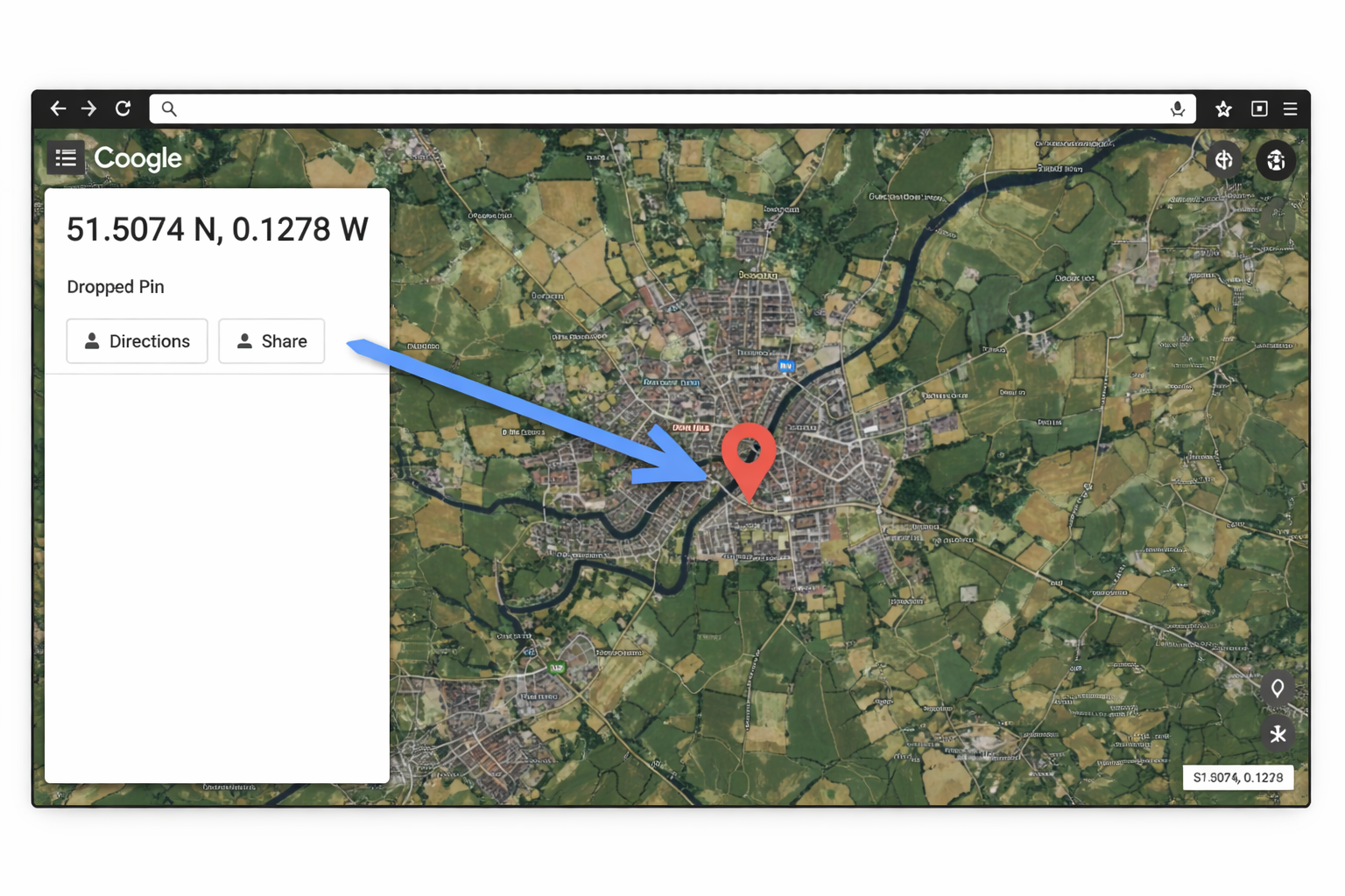
- Tap and hold your finger on an unmapped area of the screen. Do not tap an existing business icon or landmark name, as this will simply open its existing profile.
- Keep holding your finger down until a red pin drops onto the map.
- Look at the search bar at the top of the screen. The GPS coordinates will often appear directly in the search box.
- Alternatively, look at the bottom of the screen. Swipe up on the "Dropped Pin" information panel. You will see the latitude and longitude listed alongside the location details.
- Tap the coordinates to copy them to your phone's clipboard.
How to Copy and Use Coordinates from Google Maps
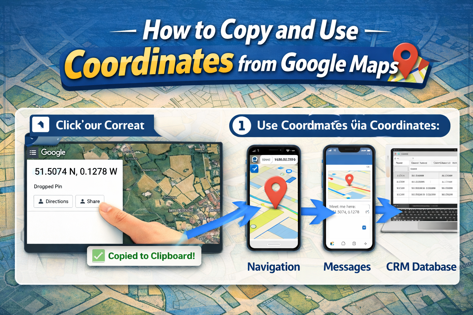
Once you figure out how to copy coordinates from Google Maps, you need to know how to use them effectively. When you paste the numbers, you will notice they always follow a specific format: latitude first, followed by a comma, and then longitude.
To use these coordinates, you can simply paste them back into the search bar of Google Maps or any other navigation system. The map will instantly snap to that exact location.
Make sure you do not alter the formatting when pasting the data. Removing the comma or changing a negative sign to a positive sign will send you to a completely different part of the world. For instance, removing the negative sign from a longitude coordinate might move your destination from New York to China.
You can paste these numbers into delivery instructions, share them via text message for precise meeting spots, or store them in customer relationship management (CRM) software to track client locations.
Common Use Cases of GPS Coordinates
Most people rely on standard street addresses for everyday navigation. However, addresses often fall short in specific scenarios. Knowing how to grab precise coordinates solves many modern logistical and business challenges.
Navigation
Street addresses do not exist everywhere. If you enjoy hiking, off-roading, or exploring rural areas, GPS coordinates are absolutely essential. They allow you to mark trailheads, camp setups, or scenic overlooks that lack formal roads. They are also incredibly helpful for finding exact entrances to large venues, like massive hospital complexes or sprawling university campuses, where a single street address covers hundreds of acres.
Business Listings
When setting up a new local business listing, mapping platforms need to know exactly where you operate. Sometimes, new developments or rural commercial spaces do not register correctly on standard maps. By providing exact coordinates, business owners ensure their storefront shows up precisely where it belongs. This prevents frustrated customers from driving to the wrong end of a shopping center.
Delivery & Logistics
The delivery and logistics industry relies heavily on coordinate data. A standard address might take a driver to the front door of a massive retail store, but the actual delivery needs to happen at a specific loading dock in the back alley. By using latitude and longitude, dispatchers can route trucks to the exact bay door, saving fuel, reducing idle time, and increasing daily delivery volume.
Local SEO & Lead Generation
Marketers and local SEO experts use coordinates to build advanced location-based campaigns. When creating service area maps or optimizing location pages, precise data points help define regional boundaries. Geotargeting campaigns run much smoother when you can drop pins exactly where your ideal customers live or work.
How Businesses Use GPS Coordinates for Lead Generation
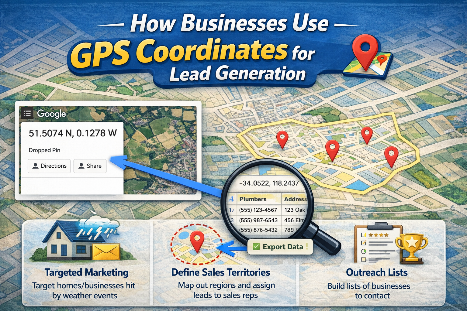
Lead generation requires deep understanding of your target market's location. Modern businesses use geographic data to visualize where their potential clients are clustered.
For example, a roofing company might want to target neighborhoods recently hit by a severe hailstorm. By plotting the storm's path using exact coordinates, they can map out the precise streets affected. They can then collect data on homes and businesses within that exact radius to send highly targeted direct mail or digital advertisements.
Similarly, B2B companies use coordinates to map out competitor locations. If you sell commercial restaurant equipment, you might plot the coordinates of every new restaurant opening in a specific city grid. This geographic visualization helps sales teams plan efficient routes for in-person visits, ensuring they do not waste time driving back and forth across town.
Limitations of Manual Coordinate Collection
While the manual steps outlined above are perfect for personal use, they quickly become a massive bottleneck for businesses.
Imagine you need to collect the location data for 500 different plumbing companies across a single state. Clicking on each business, right-clicking to grab the coordinates, and pasting them into a spreadsheet will take hours, if not days.
Manual collection also introduces a high risk of human error. It is incredibly easy to accidentally paste over a previous cell in your spreadsheet or miss a decimal point. A single missing negative sign renders the data completely useless for routing or mapping purposes.
Furthermore, as your business grows, manually checking and updating this data becomes impossible to scale. You cannot build a responsive, data-driven marketing campaign when your team is stuck doing tedious data entry tasks.
How to Automatically Extract GPS Coordinates Using a Tool
If you want to collect business data at scale and save immense amounts of time compared to manual methods, you need to automate the process. Instead of right-clicking hundreds of times, you can use specialized software to do the heavy lifting for you.
The best way to extract latitude and longitude automatically is by using a dedicated scraping tool. These tools navigate the map, identify the businesses or locations you specify, and pull all the relevant data into a neat, organized file.
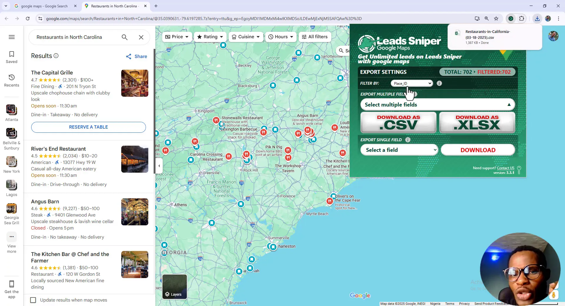
For businesses looking to streamline their lead generation and marketing efforts, we highly recommend checking out https://www.leads-sniper.com/products/google-maps-scraper.
This tool takes the tedious work out of data collection. You simply enter your search parameters, and the software works in the background to gather exact GPS coordinates, business names, contact information, and more. It transforms a task that would take a human researcher a full week into a process that takes just a few minutes.
Why Leads Sniper Google Maps Scraper is a Better Solution
Using the Leads Sniper Google Maps Scraper offers several massive advantages for businesses focused on growth and efficiency.
First, it features incredibly fast data extraction. The software can process hundreds of business profiles in a fraction of the time it takes a human. This allows your sales and marketing teams to act on fresh data immediately rather than waiting for manual lists to be compiled.
Second, it allows for bulk GPS coordinate collection. You are not limited to one search or one location at a time. You can extract massive lists of geographic data, perfectly formatted and ready to import directly into your CRM or mapping software.
Third, the user-friendly interface makes it accessible for anyone. You do not need a background in coding or data science to operate the scraper. The intuitive dashboard walks you through the setup process, ensuring you get exactly the data you need without any technical headaches.
Finally, it provides scalable lead generation. As your business expands into new cities or states, the tool easily scales with you. You can pull precise location data for any market in the world, giving you a distinct competitive advantage in local targeting.
Tips for Using GPS Coordinates Effectively
To get the most out of your location data, keep a few best practices in mind.
Always double-check your formatting. As mentioned earlier, Google Maps prefers decimal degrees. Ensure your latitude and longitude are separated by a single comma and a space.
Pay close attention to negative signs. A negative latitude means the location is south of the Equator, while a negative longitude means it is west of the Prime Meridian. The entire United States, for example, uses positive latitudes and negative longitudes.
If you are sharing coordinates with someone who uses a different navigation system, be aware that some older GPS units use Degrees, Minutes, and Seconds (DMS) format. You may need to use a free online converter to translate your decimal coordinates into DMS format for compatibility.
FAQs
How accurate are Google Maps coordinates?
They are incredibly accurate, usually pinpointing a location within a few meters. They are more than precise enough for standard navigation, business targeting, and delivery routing.
Can I find GPS coordinates on mobile?
Yes. You can find them on both Android and iPhone devices by dropping a pin on an unmapped area of the map and looking at the details panel or search bar.
What format does Google Maps use for coordinates?
It primarily uses decimal degrees (DD). The format displays the latitude first, followed by a comma, and then the longitude (e.g., 34.0522, -118.2437).
How do I convert coordinates?
If you need to switch between decimal degrees and Degrees, Minutes, and Seconds (DMS), you can use a free online coordinate converter. Alternatively, if you paste DMS coordinates into the map search bar, it will automatically process them and show you the decimal equivalent.
Can I search by coordinates instead of an address?
Absolutely. Just paste the exact latitude and longitude directly into the search bar, and the map will instantly take you to that specific geographic point.
Conclusion
Understanding how to find GPS coordinates on Google Maps is a valuable skill for personal navigation and an essential strategy for modern business operations. Whether you need to locate a remote trail, direct a delivery truck to a specific bay, or map out competitors, latitude and longitude provide the exact precision that standard addresses lack.
While manual extraction works fine for one-off searches, it quickly becomes an impossible hurdle for growing businesses. Automated extraction changes the game entirely.
If you want to stop wasting time on manual data entry and start building highly targeted location-based campaigns, automation is the key. Equip your team with the right tools to pull bulk data effortlessly. Check out the Leads Sniper Google Maps Scraper today and supercharge your local lead generation efforts.


